Simojoki vesiretkeilyreitti follows one of Finland’s best-known wilderness paddling rivers from the Ranua area toward the Gulf of Bothnia: a long point-to-point river journey on the Simojoki, mapped at about 178 km on our line. The Simojoki rises from Lake Simojärvi and runs through southern Lapland to the sea; it is t...
City of Simo – Tourism+
Description
Simojoki vesiretkeilyreitti follows one of Finland’s best-known wilderness paddling rivers from the Ranua area toward the Gulf of Bothnia: a long point-to-point river journey on the Simojoki, mapped at about 178 km on our line. The Simojoki rises from Lake Simojärvi and runs through southern Lapland to the sea; it is the only entirely Finnish river with its own naturally breeding Atlantic salmon stock, and it is protected as a Natura 2000 site for natural river habitats, as described by the Finnish Environment Institute. The City of Simo promotes the valley for fishing, trekking, and canoeing, and points visitors to Simojoki.com for licences, services, and the municipal map hub. In practice this is a multi-day expedition: dozens of rapids range from easy class I runs to harder class II and II+ sections on the lower river, so water level, skill, and careful line choice matter. The Jaloittelua blog documents a full-length descent with long daily stages, class I–II+ rapids, cold water even in summer, and the value of good maps when rapids come in quick succession. Along the mapped line you pass resting places that suit overnight and lunch stops, including Hömmönkoski, Jokikangas, Kupusen niitty, and Kutuvaara lean-tos and parking areas tied to the river corridor. Near Alaniemi, commercial operators serve anglers and paddlers: Simojoen Lohiranta offers canoe and kayak rental with shuttle service beside the river, and Lapinkoski’s introduction material places well-known fishing pools such as Hömmönkoski in the same Alaniemi reach. Respect private land, salmon angling rules, and seasonal closures if you combine paddling with fishing—Simojoki.com summarizes the need for a municipal licence on the Simo reach plus the national fisheries management fee. Ranua anchors the listing, but the river itself crosses several municipalities; Lapland’s open landscapes and peatland-backed banks dominate the middle and lower reaches.
Length & route
The mapped route is about 178 km as one continuous line along the Simojoki, from the southern Lapland headwater country toward the coast. It is not a loop. The Finnish Environment Institute records about 193 km from Simojärvi to the sea for the full river, roughly 176 m of drop, and almost 40 km of rapid channels in total—illustrating how much of the distance is moving water rather than flat lake. Day distances on a full descent vary with skill and water level; independent trip reports used stages on the order of 25–46 km on longer days when conditions allowed. Rapids are numerous; many sections are straightforward class I, but class II and harder II+ rapids appear on the lower river, so scouting and portaging may be needed.
Getting there
Most paddlers plan put-in and take-out around road access along the Simojoki valley—local roads follow much of the river, and the City of Simo highlights map services and service points on Simojoki.com. Hömmönkoski and Jokikangas on our map offer named parking and lean-tos within a few tens of kilometres from the upper–middle transition; Kupusen niitty and Kutuvaara add rest spots farther downstream. Simojoen Lohiranta at Ranuantie 219 B in Alaniemi advertises daily hours, canoe and kayak rental, and shuttle service for visitors. Kemi–Tornio and Oulu airports are within a few hours’ drive for international visitors heading to the lower river.
Good to know
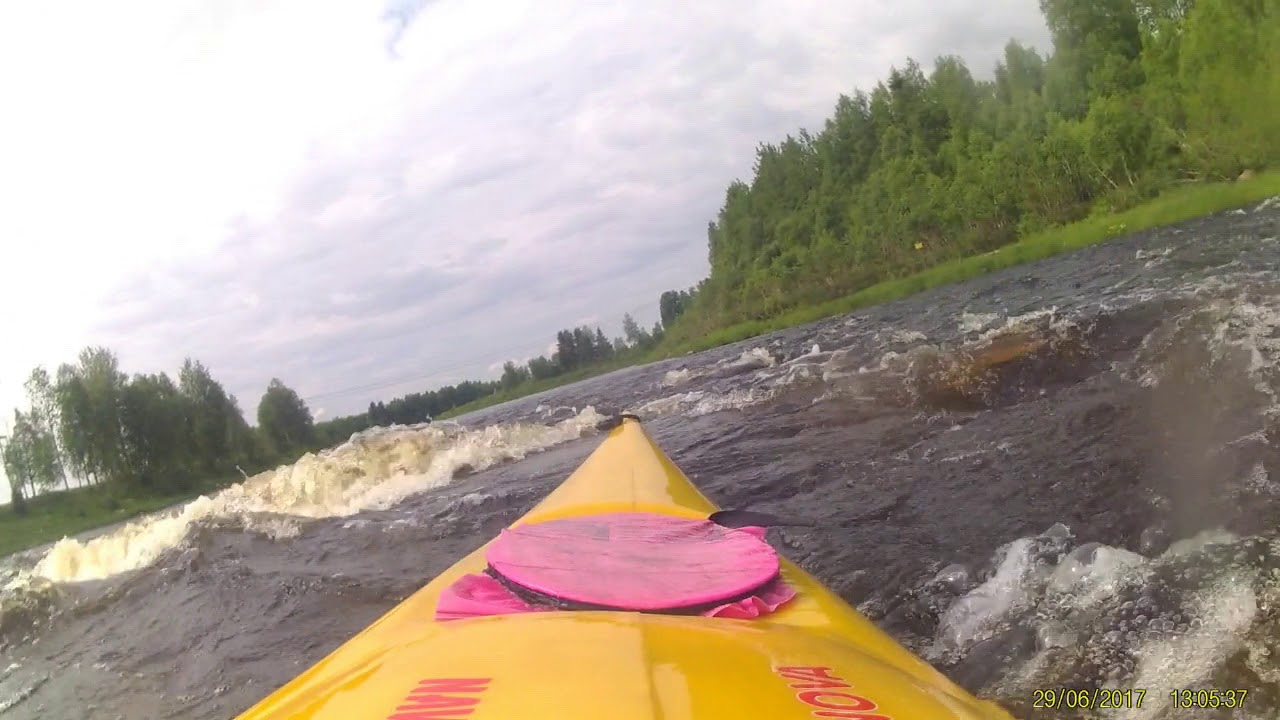
Wear a dry suit or splash gear outside midsummer: even warm air can leave river water cold, and spray from rapids cools you quickly. If you fish from a kayak with rod and lure, check current Simojoki licence rules on Simojoki.com—municipal waters on the Simo reach need their own permit in addition to the national fisheries management fee where applicable. Give anglers and drift boats space at famous pools such as Hömmönkoski. A short rapid clip from the Simojoki (“Koskessa Simojoessa”) illustrates the character of the white water in context. On land, winter routes such as the Ranua - Ii - Simo moottorikelkkareitti sometimes follow the same broad valley; they do not replace on-water judgement.
History
Salmon fishing shaped Simojoki’s cultural landscape for centuries. The City of Simo notes that nineteenth-century log driving works and later restoration and salmon management returned the river to prominence as a sport fishery, with world fly-fishing championships held on the river in 2007. The Finnish Environment Institute summarizes twentieth-century damming and channel works for timber floating, later removal of storage dams, and ongoing habitat work affecting summer flows.
Itinerary
Example staging using places along the mapped line (adjust to flow and skill): Days 1–2 — Upper Simojoki and lake-linked sections toward the middle reaches; use parking and services near Simon and Ranua road access where the line crosses settled ground. Around 27 km along the line, Hömmönkoski clusters parking with lean-tos for a natural break on multi-day trips. Days 3–5 — Middle river: near 43–44 km, Jokikangas offers a lean-to, dry toilet, and parking for a camp night or resupply stop beside the bank. Days 6–8 — Lower middle: near 79 km, Kupusen niitty combines lean-to, parking, and toilet in one riverside cluster. Days 9+ — Approaching the coastal plain: near 152 km, Kutuvaaran laavu supports a late-stage overnight before the final flatter water and any sea crossing to a harbour take-out; independent journals ended at a small-boat harbour after the last rapids and a short sea paddle. Treat daily kilometres as flexible: high water can speed lines but also hide rocks; low water can mean more lining and shorter days.
Where to rent kayaks
Simojoen Lohiranta at Ranuantie 219 B, 95255 Alaniemi, advertises canoe and kayak rental with shuttle service, daily service hours, and contact via info@simojoen-lohiranta.fi and +358 400 691 351. Lapinkoski in the Alaniemi area markets the Simojoki fishing destination and notes rental options including sit-on-top fishing kayaks and river boats for use on Simojoki or nearby waters—check their current equipment pages when planning.
Guided tours & Experiences
Simojoen Lohiranta listaa ohjattuja lohikalastusretkiä ja ohjelmapalveluja vuokrauksen ohella. Lapinkoski tarjoaa opastettuja kalastuspalveluja ja opetuksellisia lohen perhokalastuskursseja Simojoella; ohjelmat ja varaus hoidetaan heidän kauppansa ja opaspalvelujensa kautta. Painotus on kalastuksessa, mutta ne hyödyttävät, jos haluat paikallisasiantuntemusta samalle jokikäytävälle.
Downstream along the Simojoki from the headwater lakes toward the Gulf of Bothnia; logistics and wind may make upstream shuttles rare for end-to-end trips.
Route direction
Open / Good Condition
Open / Good Condition
Activities allowed
Kayak / Canoe
Activity
Terrain & conditions
178.4 km
Distance
typically several full days to well over a week for the whole mapped distance, depending on water level and risk tolerance
Be the first to write a review for "Simojoki vesiretkeilyreitti"
Share a photo from a recent trip
Answers to your questions
Our data was researched from Ranua, and other trusted sources, in March 2026. Our route / place GPX data comes from Metsähallitus / Lipas, last updated March 2026. Always check their official website for safety-critical updates.
Short on-river clip from a Simojoki rapid (Koskessa Simojoessa), useful for visualizing rapid character.
Description
Simojoki vesiretkeilyreitti follows one of Finland’s best-known wilderness paddling rivers from the Ranua area toward the Gulf of Bothnia: a long point-to-point river journey on the Simojoki, mapped at about 178 km on our line. The Simojoki rises from Lake Simojärvi and runs through southern Lapland to the sea; it is t...
City of Simo – Tourism+
Description
Simojoki vesiretkeilyreitti follows one of Finland’s best-known wilderness paddling rivers from the Ranua area toward the Gulf of Bothnia: a long point-to-point river journey on the Simojoki, mapped at about 178 km on our line. The Simojoki rises from Lake Simojärvi and runs through southern Lapland to the sea; it is the only entirely Finnish river with its own naturally breeding Atlantic salmon stock, and it is protected as a Natura 2000 site for natural river habitats, as described by the Finnish Environment Institute. The City of Simo promotes the valley for fishing, trekking, and canoeing, and points visitors to Simojoki.com for licences, services, and the municipal map hub. In practice this is a multi-day expedition: dozens of rapids range from easy class I runs to harder class II and II+ sections on the lower river, so water level, skill, and careful line choice matter. The Jaloittelua blog documents a full-length descent with long daily stages, class I–II+ rapids, cold water even in summer, and the value of good maps when rapids come in quick succession. Along the mapped line you pass resting places that suit overnight and lunch stops, including Hömmönkoski, Jokikangas, Kupusen niitty, and Kutuvaara lean-tos and parking areas tied to the river corridor. Near Alaniemi, commercial operators serve anglers and paddlers: Simojoen Lohiranta offers canoe and kayak rental with shuttle service beside the river, and Lapinkoski’s introduction material places well-known fishing pools such as Hömmönkoski in the same Alaniemi reach. Respect private land, salmon angling rules, and seasonal closures if you combine paddling with fishing—Simojoki.com summarizes the need for a municipal licence on the Simo reach plus the national fisheries management fee. Ranua anchors the listing, but the river itself crosses several municipalities; Lapland’s open landscapes and peatland-backed banks dominate the middle and lower reaches.
Length & route
The mapped route is about 178 km as one continuous line along the Simojoki, from the southern Lapland headwater country toward the coast. It is not a loop. The Finnish Environment Institute records about 193 km from Simojärvi to the sea for the full river, roughly 176 m of drop, and almost 40 km of rapid channels in total—illustrating how much of the distance is moving water rather than flat lake. Day distances on a full descent vary with skill and water level; independent trip reports used stages on the order of 25–46 km on longer days when conditions allowed. Rapids are numerous; many sections are straightforward class I, but class II and harder II+ rapids appear on the lower river, so scouting and portaging may be needed.
Getting there
Most paddlers plan put-in and take-out around road access along the Simojoki valley—local roads follow much of the river, and the City of Simo highlights map services and service points on Simojoki.com. Hömmönkoski and Jokikangas on our map offer named parking and lean-tos within a few tens of kilometres from the upper–middle transition; Kupusen niitty and Kutuvaara add rest spots farther downstream. Simojoen Lohiranta at Ranuantie 219 B in Alaniemi advertises daily hours, canoe and kayak rental, and shuttle service for visitors. Kemi–Tornio and Oulu airports are within a few hours’ drive for international visitors heading to the lower river.
Good to know
Wear a dry suit or splash gear outside midsummer: even warm air can leave river water cold, and spray from rapids cools you quickly. If you fish from a kayak with rod and lure, check current Simojoki licence rules on Simojoki.com—municipal waters on the Simo reach need their own permit in addition to the national fisheries management fee where applicable. Give anglers and drift boats space at famous pools such as Hömmönkoski. A short rapid clip from the Simojoki (“Koskessa Simojoessa”) illustrates the character of the white water in context. On land, winter routes such as the Ranua - Ii - Simo moottorikelkkareitti sometimes follow the same broad valley; they do not replace on-water judgement.
History
Salmon fishing shaped Simojoki’s cultural landscape for centuries. The City of Simo notes that nineteenth-century log driving works and later restoration and salmon management returned the river to prominence as a sport fishery, with world fly-fishing championships held on the river in 2007. The Finnish Environment Institute summarizes twentieth-century damming and channel works for timber floating, later removal of storage dams, and ongoing habitat work affecting summer flows.
Itinerary
Example staging using places along the mapped line (adjust to flow and skill): Days 1–2 — Upper Simojoki and lake-linked sections toward the middle reaches; use parking and services near Simon and Ranua road access where the line crosses settled ground. Around 27 km along the line, Hömmönkoski clusters parking with lean-tos for a natural break on multi-day trips. Days 3–5 — Middle river: near 43–44 km, Jokikangas offers a lean-to, dry toilet, and parking for a camp night or resupply stop beside the bank. Days 6–8 — Lower middle: near 79 km, Kupusen niitty combines lean-to, parking, and toilet in one riverside cluster. Days 9+ — Approaching the coastal plain: near 152 km, Kutuvaaran laavu supports a late-stage overnight before the final flatter water and any sea crossing to a harbour take-out; independent journals ended at a small-boat harbour after the last rapids and a short sea paddle. Treat daily kilometres as flexible: high water can speed lines but also hide rocks; low water can mean more lining and shorter days.
Where to rent kayaks
Simojoen Lohiranta at Ranuantie 219 B, 95255 Alaniemi, advertises canoe and kayak rental with shuttle service, daily service hours, and contact via info@simojoen-lohiranta.fi and +358 400 691 351. Lapinkoski in the Alaniemi area markets the Simojoki fishing destination and notes rental options including sit-on-top fishing kayaks and river boats for use on Simojoki or nearby waters—check their current equipment pages when planning.
Guided tours & Experiences
Simojoen Lohiranta listaa ohjattuja lohikalastusretkiä ja ohjelmapalveluja vuokrauksen ohella. Lapinkoski tarjoaa opastettuja kalastuspalveluja ja opetuksellisia lohen perhokalastuskursseja Simojoella; ohjelmat ja varaus hoidetaan heidän kauppansa ja opaspalvelujensa kautta. Painotus on kalastuksessa, mutta ne hyödyttävät, jos haluat paikallisasiantuntemusta samalle jokikäytävälle.
Downstream along the Simojoki from the headwater lakes toward the Gulf of Bothnia; logistics and wind may make upstream shuttles rare for end-to-end trips.
Be the first to write a review for "Simojoki vesiretkeilyreitti"
Share a photo from a recent trip
Answers to your questions
Our data was researched from Ranua, and other trusted sources, in March 2026. Our route / place GPX data comes from Metsähallitus / Lipas, last updated March 2026. Always check their official website for safety-critical updates.