On our map this route follows about 134 km of open-water and river line across South Karelia’s Saimaa network—one continuous trace from authority GIS. Brochure-style descriptions often describe the classic through-paddle as roughly 110 km depending on where you start and finish, which shortcuts you take between arms of...
Visit Ruokolahti – Muut aktiviteetit+
Description
On our map this route follows about 134 km of open-water and river line across South Karelia’s Saimaa network—one continuous trace from authority GIS. Brochure-style descriptions often describe the classic through-paddle as roughly 110 km depending on where you start and finish, which shortcuts you take between arms of the system, and whether you measure harbour-to-harbour or full shoreline-following geometry. Visit Ruokolahti positions the Ruokolahti kayaking route as a long lake-and-river tour: sheltered bays and river links, historic dug canals such as the Kutvele, Käyhkää, and Kukonharju passages, and wide Saimaa reaches before you close in near Ruokolahti centre. GoSaimaa highlights the same corridor—about 110 km in their summary—with optional detours toward the Katosselkä protection area and a realistic chance to spot Saimaa ringed seals where conditions suit. The regional outdoor catalogue Etelä-Karjala retkeily lists the same paddling entry for trip planning alongside other South Karelia routes.
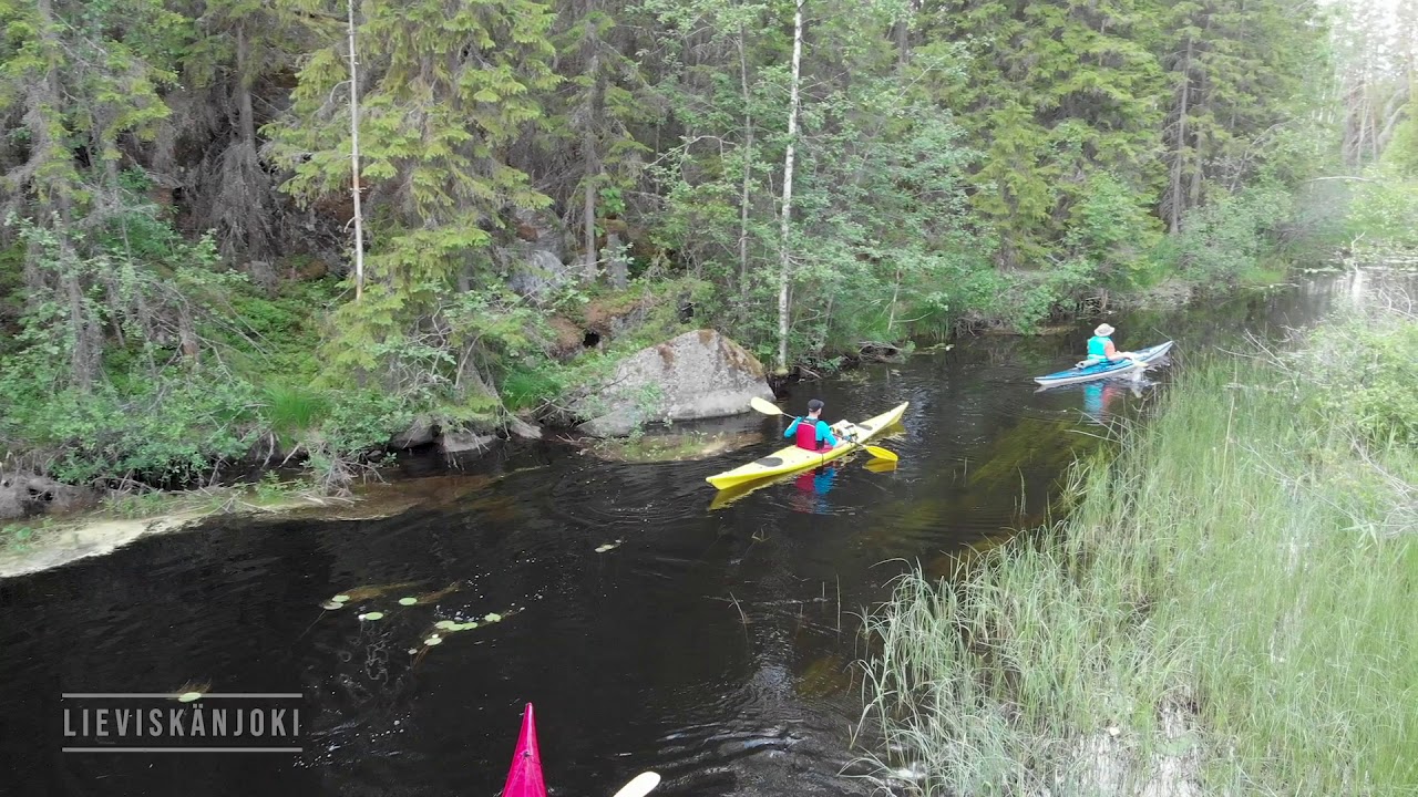
Along the mapped line, the staging reads like a multi-day expedition broken into distinct water rooms. Kukonharjun kanava - veneenlaskupaikka sits on the canal thread when you move through the Kukonharju reach; Savonkaita lähtöpaikka and Savonkaidan laavu pair with Kemppilän myllykoski - veneenlaskupaikka and Mikonpolven laavu where portages and mill-side breaks dominate the day’s rhythm. Lieviskän mylly - veneenlaskupaikka, Hiekkaniemi veneenlaskupaikka, and Hiekkaniemen laavu Ruokolahti line the shore before wider fetches; Mustaniemen rantautumispaikka and Mustaniemen laavu give another landing pair on big water. Further south, Patasaari - veneenlaskupaikka, Huuhanrannan laavu - Etelä-Karjalan virkistysaluesäätiö, and Karoniemen laavu support overnight pacing, and the town end passes Laskettelukeskus FreeSki beside Vaittilan uimapaikka and Rasilan uimapaikka when you seek services and rental returns.
Equipment and logistics are part of the story. Saimaa Bikepark runs kayak and canoe rental beside the Ukonsalmi bridge at Salosaari, offers shuttle-style transport for boats and paddlers to chosen start or end points, and publishes seasonal desk hours rather than all-day walk-in service—check before you commit to a tight schedule. Visit Ruokolahti also lists Discover Saimaa’s river-base rentals near Lieviskänjoki’s mouth, Katosselän Kanootit’s full-service outfit on the Puumala–Ruokolahti boundary, and Hotelli Hirsiranta’s SUP and kayak hire from the shoreline hotel—useful if you want a shorter day loop or a second vehicle staged away from the main harbour end. For a candid on-the-ground read of Savonkaita–Lieviskän moods, wind, and mill portages, Karelia Adventure’s multi-day trip notes reward a slow read even though every season differs.
If you link land travel with the water corridor, the regional cycling route Kolmen lossin kierros shares some shore infrastructure around the Lieviskän area; Imatran melontareitit is another regional multi-day option when you are already touring South Karelia’s paddling pages. Fishing from the craft follows normal inland permit rules; Visit Ruokolahti summarises the basics and points to regional permit detail for Haapavesi and Saimaa-specific protections—carry current rules before you cast.
Length & route
The mapped line is about 134.3 km as one continuous paddle in this database. Tourism copy for the classic Ruokolahti through-route often cites near 110 km harbour-to-harbour-style distances while still describing the same major water rooms, canals, and portage pairs. Two land carries are routinely named for trip planning: a short carry at the Lieviskä bridge reach and a longer carry at the Kemppilä mill rapids—order and exact metres vary slightly between brochure PDFs and paddlers’ field notes, but both appear as real portage work in independent trip reports as well as official summaries. Expect mixed lake, river, and canal paddling with occasional motor-wake exposure on busy fairways near bridges and channels.
Getting there
Treat the Ruokolahti route as a shuttle: match put-in and take-out to public launches and rental hubs rather than assuming a single signed trailhead. Visit Ruokolahti describes shorter loops such as a Salosaari circuit and a two-day Äitsaari tour with overnight at Karoniemen laavu, with practical starts from Vaittilan uimaranta or Ruokolahti harbour—use those names when aligning cars and boats. Saimaa Bikepark stages hire and returns at Lomatie 16, Salosaari, and advertises transport to alternate starts or finishes—confirm times against their published summer desk hours. Discover Saimaa’s river base at Ihalantie 816, Sulkava, suits paddlers who want to stage near Lieviskänjoki’s mouth rather than the central harbour end.
Good to know
Motor traffic can be lively near canals and road bridges—give powered craft a wide berth and watch for wake when you pause for food. Forest-fire and camping rules still apply at laavu and campfire places; independent bloggers remind you that total fire bans can force cold meals even when shelters look inviting. Seal encounters are possible but never guaranteed—keep distance and avoid disturbing animals in shallow bays.
Itinerary
At about 134 km on our line, plan several full days unless you are racing flat water. A practical reading of the stop list clusters the first long day from Savonkaita and river links toward Kemppilän myllykoski and Lieviskän mill launches—where portages and mill-side laavu breaks eat time even when kilometre counts look modest. A middle block crosses broader Saimaa arms toward Hiekkaniemi and Mustaniemi landing pairs, good for pairing beach time with laavu shelter when weather turns. Further south, Patasaari launch, Huuhanrannan laavu, and Karoniemen laavu support multi-night pacing before you approach Ruokolahti’s sports fields, harbour-side swims, and the FreeSki shore cluster where Bikepark’s canoe base sits—use that end for rental returns and town services. If wind builds on long fetches, shorten daily targets and favour lee behind islands as described in regional tourism copy and paddlers’ blogs.
Where to rent kayaks
Saimaa Bikepark rents kayaks and canoes with accessories at Salosaari (Lomatie 16), offers paddler-and-boat shuttles, and posts seasonal opening hours for 2025—phone 0400 889 851 and email via their melonta page. Discover Saimaa operates a river paddling base at Ihalantie 816, Sulkava, with self-hire and guided options—041 313 6868 and info@discoversaimaa.fi. Katosselän Kanootit provides full-service canoe and e-bike hire plus transports near the Puumala–Ruokolahti boundary at Reposenniementie 37a, Puumala—0400 150 276. Hotelli Hirsiranta rents SUP boards and kayaks from Lomahovintie 3 with beach and kota access—044 231 8532 and info@hirsiranta.fi.
Guided tours & Experiences
Discover Saimaa advertises guided paddling and nature experiences across South Karelia and South Savo from its river bases, including equipment hire on route. Saimaa Bikepark arranges instruction and guided trips with partner operators by arrangement.
Most paddlers describe downstream or lake-linking progress from northern lake rooms toward Ruokolahti services and rental return points, but the network can be boated in either direction with equivalent portage work.
Route direction
Archipelago
Archipelago
Lake
Lake
River
River
Open / Good Condition
Open / Good Condition
Visit Ruokolahti – Muut aktiviteetit+
Activities allowed
Kayak / Canoe
Activity
Terrain & conditions
134.3 km
Distance
Typically four to seven full paddling days for the full mapped line in normal summer weather, or shorter if you shuttle and skip sections; brochure distances near 110 km still imply multi-day timing for most groups.
Be the first to write a review for "Ruokolahti kayaking route"
Share a photo from a recent trip
Answers to your questions
Our data was researched from Ruokolahti, and other trusted sources, in March 2026. Our route / place GPX data comes from Metsähallitus / Lipas, last updated March 2026. Always check their official website for safety-critical updates.
Overview video titled Ruokolahden melontareitti from Etelä-Karjalan virkistysaluesäätiö, showing the South Karelia paddling corridor on Lake Saimaa.
Description
On our map this route follows about 134 km of open-water and river line across South Karelia’s Saimaa network—one continuous trace from authority GIS. Brochure-style descriptions often describe the classic through-paddle as roughly 110 km depending on where you start and finish, which shortcuts you take between arms of...
Visit Ruokolahti – Muut aktiviteetit+
Description
On our map this route follows about 134 km of open-water and river line across South Karelia’s Saimaa network—one continuous trace from authority GIS. Brochure-style descriptions often describe the classic through-paddle as roughly 110 km depending on where you start and finish, which shortcuts you take between arms of the system, and whether you measure harbour-to-harbour or full shoreline-following geometry. Visit Ruokolahti positions the Ruokolahti kayaking route as a long lake-and-river tour: sheltered bays and river links, historic dug canals such as the Kutvele, Käyhkää, and Kukonharju passages, and wide Saimaa reaches before you close in near Ruokolahti centre. GoSaimaa highlights the same corridor—about 110 km in their summary—with optional detours toward the Katosselkä protection area and a realistic chance to spot Saimaa ringed seals where conditions suit. The regional outdoor catalogue Etelä-Karjala retkeily lists the same paddling entry for trip planning alongside other South Karelia routes.
Along the mapped line, the staging reads like a multi-day expedition broken into distinct water rooms. Kukonharjun kanava - veneenlaskupaikka sits on the canal thread when you move through the Kukonharju reach; Savonkaita lähtöpaikka and Savonkaidan laavu pair with Kemppilän myllykoski - veneenlaskupaikka and Mikonpolven laavu where portages and mill-side breaks dominate the day’s rhythm. Lieviskän mylly - veneenlaskupaikka, Hiekkaniemi veneenlaskupaikka, and Hiekkaniemen laavu Ruokolahti line the shore before wider fetches; Mustaniemen rantautumispaikka and Mustaniemen laavu give another landing pair on big water. Further south, Patasaari - veneenlaskupaikka, Huuhanrannan laavu - Etelä-Karjalan virkistysaluesäätiö, and Karoniemen laavu support overnight pacing, and the town end passes Laskettelukeskus FreeSki beside Vaittilan uimapaikka and Rasilan uimapaikka when you seek services and rental returns.
Equipment and logistics are part of the story. Saimaa Bikepark runs kayak and canoe rental beside the Ukonsalmi bridge at Salosaari, offers shuttle-style transport for boats and paddlers to chosen start or end points, and publishes seasonal desk hours rather than all-day walk-in service—check before you commit to a tight schedule. Visit Ruokolahti also lists Discover Saimaa’s river-base rentals near Lieviskänjoki’s mouth, Katosselän Kanootit’s full-service outfit on the Puumala–Ruokolahti boundary, and Hotelli Hirsiranta’s SUP and kayak hire from the shoreline hotel—useful if you want a shorter day loop or a second vehicle staged away from the main harbour end. For a candid on-the-ground read of Savonkaita–Lieviskän moods, wind, and mill portages, Karelia Adventure’s multi-day trip notes reward a slow read even though every season differs.
If you link land travel with the water corridor, the regional cycling route Kolmen lossin kierros shares some shore infrastructure around the Lieviskän area; Imatran melontareitit is another regional multi-day option when you are already touring South Karelia’s paddling pages. Fishing from the craft follows normal inland permit rules; Visit Ruokolahti summarises the basics and points to regional permit detail for Haapavesi and Saimaa-specific protections—carry current rules before you cast.
Length & route
The mapped line is about 134.3 km as one continuous paddle in this database. Tourism copy for the classic Ruokolahti through-route often cites near 110 km harbour-to-harbour-style distances while still describing the same major water rooms, canals, and portage pairs. Two land carries are routinely named for trip planning: a short carry at the Lieviskä bridge reach and a longer carry at the Kemppilä mill rapids—order and exact metres vary slightly between brochure PDFs and paddlers’ field notes, but both appear as real portage work in independent trip reports as well as official summaries. Expect mixed lake, river, and canal paddling with occasional motor-wake exposure on busy fairways near bridges and channels.
Getting there
Treat the Ruokolahti route as a shuttle: match put-in and take-out to public launches and rental hubs rather than assuming a single signed trailhead. Visit Ruokolahti describes shorter loops such as a Salosaari circuit and a two-day Äitsaari tour with overnight at Karoniemen laavu, with practical starts from Vaittilan uimaranta or Ruokolahti harbour—use those names when aligning cars and boats. Saimaa Bikepark stages hire and returns at Lomatie 16, Salosaari, and advertises transport to alternate starts or finishes—confirm times against their published summer desk hours. Discover Saimaa’s river base at Ihalantie 816, Sulkava, suits paddlers who want to stage near Lieviskänjoki’s mouth rather than the central harbour end.
Good to know
Motor traffic can be lively near canals and road bridges—give powered craft a wide berth and watch for wake when you pause for food. Forest-fire and camping rules still apply at laavu and campfire places; independent bloggers remind you that total fire bans can force cold meals even when shelters look inviting. Seal encounters are possible but never guaranteed—keep distance and avoid disturbing animals in shallow bays.
Itinerary
At about 134 km on our line, plan several full days unless you are racing flat water. A practical reading of the stop list clusters the first long day from Savonkaita and river links toward Kemppilän myllykoski and Lieviskän mill launches—where portages and mill-side laavu breaks eat time even when kilometre counts look modest. A middle block crosses broader Saimaa arms toward Hiekkaniemi and Mustaniemi landing pairs, good for pairing beach time with laavu shelter when weather turns. Further south, Patasaari launch, Huuhanrannan laavu, and Karoniemen laavu support multi-night pacing before you approach Ruokolahti’s sports fields, harbour-side swims, and the FreeSki shore cluster where Bikepark’s canoe base sits—use that end for rental returns and town services. If wind builds on long fetches, shorten daily targets and favour lee behind islands as described in regional tourism copy and paddlers’ blogs.
Where to rent kayaks
Saimaa Bikepark rents kayaks and canoes with accessories at Salosaari (Lomatie 16), offers paddler-and-boat shuttles, and posts seasonal opening hours for 2025—phone 0400 889 851 and email via their melonta page. Discover Saimaa operates a river paddling base at Ihalantie 816, Sulkava, with self-hire and guided options—041 313 6868 and info@discoversaimaa.fi. Katosselän Kanootit provides full-service canoe and e-bike hire plus transports near the Puumala–Ruokolahti boundary at Reposenniementie 37a, Puumala—0400 150 276. Hotelli Hirsiranta rents SUP boards and kayaks from Lomahovintie 3 with beach and kota access—044 231 8532 and info@hirsiranta.fi.
Guided tours & Experiences
Discover Saimaa advertises guided paddling and nature experiences across South Karelia and South Savo from its river bases, including equipment hire on route. Saimaa Bikepark arranges instruction and guided trips with partner operators by arrangement.
Most paddlers describe downstream or lake-linking progress from northern lake rooms toward Ruokolahti services and rental return points, but the network can be boated in either direction with equivalent portage work.
Typically four to seven full paddling days for the full mapped line in normal summer weather, or shorter if you shuttle and skip sections; brochure distances near 110 km still imply multi-day timing for most groups.
Be the first to write a review for "Ruokolahti kayaking route"
Share a photo from a recent trip
Answers to your questions
Our data was researched from Ruokolahti, and other trusted sources, in March 2026. Our route / place GPX data comes from Metsähallitus / Lipas, last updated March 2026. Always check their official website for safety-critical updates.